
Fires burning in Brazil’s Pantanal in Mato Grosso state on Sept. 9. The world’s largest tropical wetland is suffering a second year of burning after drought helped flames spread. Photographer: Jonne Roriz/Bloomberg
Time Is Running Out to Save the Last of the World’s Rainforest
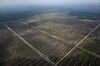
Fires are burning once more across the equatorial forests of South America, Africa, and Asia, bringing a familiar wave of outrage on social media and concern from investors. This has led to an equally familiar set of promises from governments to halt destruction on those continents. Will it make any difference?
The short answer is no. According to the Rainforest Action Network, a San Francisco-based environmental pressure group, forests have been vanishing at a rate of about 1 acre every two seconds. Using satellite images, land-use maps, and government data going back almost a century, Bloomberg tracked how and where rainforests were destroyed and examined the geographical, human, and economic forces behind the destruction.
Tree loss in the equatorial forest from 2000 to 2016

South America
Africa
Asia
Forest
coverage
Equator

South America
Forest coverage
Equator
Africa
Asia

South America
Forest coverage
Equator
Africa
Asia
Tropical rainforests vanish because they’re logged for prized hardwoods; burned down deliberately or naturally; cleared for agriculture, mining, or urban expansion; or die off as climate change alters the local environment.
Southeast Asia, where widespread logging and commercial plantations have operated for almost a century, is a prime example of a region where all these forces are at work. Western Malaysia has dealt with them longer than most. Situated on a peninsula stretching south toward Singapore, its agricultural areas were largely confined to the coast through the mid-19th century. After the British brought rubber trees from Brazil in 1877, plantations expanded inland. Oil palms brought to Malaysia from West Africa around the same time were originally considered ornamental trees, but as rubber prices declined in the mid-20th century, the newly independent government began to push the expansion of palm oil to increase revenue from exports. By the 1990s the palm oil era was in full swing.
In the 143 years since those first rubber trees arrived, the area of original rainforest on peninsular Malaysia has shrunk by about 90%, with most of the loss occurring in the past 30 years. Land designated by the United Nations as forest still covers more than half the country, but that includes plantations, mangroves (which thrive in a very different habitat), lumber concessions, and regrowth on land that was previously cleared. The variety and complexity of the original forests have been lost.
Annual tree loss in Peninsular Malaysia

Cumulative tree loss
from 2000 to 2019
Taman Negara National Park
Less loss
More loss
Peninsular
Malaysia
Kuala Lumpur
100 miles
100 km

Cumulative tree loss
from 2000 to 2019
Taman Negara
National Park
Less loss
More loss
Peninsular
Malaysia
Kuala Lumpur
100 miles
100 km

Cumulative tree loss
from 2000 to 2019
Less loss
More loss
Taman Negara National Park
Peninsular
Malaysia
100 miles
100 km
Kuala
Lumpur
“I don’t think a clear-cut forest can ever return to its original state, especially in terms of species diversity,” says Cynthia Gerlein-Safdi, an ecohydrologist at the department of Climate and Space Sciences and Engineering at the University of Michigan. “We know from forests in temperate climates that it can take centuries for forests to recover.”
What happened in this part of Malaysia has also occurred in the eastern part of the country on the island of Borneo and in neighboring Indonesia, which is now the world’s biggest producer of palm oil.
The rapid destruction of one of the world’s most diverse habitats sparked protests, especially after the extended El Niño of 1997 delayed rains, which allowed the jungle to burn for months. The smoke caused a choking haze that spread across the region. The governments of Malaysia and neighboring Indonesia promised to clamp down on illegal fires, but it made little difference. From 2000 to 2010 the rate of forest loss in Malaysia was double that of the previous decade.
Some of Malaysia’s original forest survives. At the top of the central mountain range is Taman Negara, one of the world’s oldest patches of rainforest. It’s avoided the fate of the surrounding jungle partly because it’s inaccessible to lumber companies—western Malaysia’s highest peak, Gunung Tahan, is among its attractions—and partly because it’s been protected since the 1930s as a national park.
A study by researchers at the University of Maryland last year showed that the three main drivers of palm oil expansion are geographical suitability, proximity to a market or a port, and the infrastructure to get the trees out. They also found that most new palm oil plantations were next to or near existing ones.
In other words, the key is access. Once a palm oil industry is established in a forest, it’s likely to keep growing.
The primary reason for the destruction is, of course, money. Hardwoods are valuable, and crops like palm oil have been gold mines for developing nations. The oil is Indonesia’s second-biggest export earner after coal, bringing in more than $10 billion in 2019.
As forests were logged, burned, and replaced with lines of oil palms in Southeast Asia, lobbying groups pushed for boycotts of products from the big timber, paper, and plantation companies. Palm oil became the bête noire of the environmental movement.
But the fruit of the oil palm is one of the most versatile crops in cultivation. The tree’s high productivity and the chemical properties of the oil make it a more lucrative investment than many others in either agriculture or chemicals. Palm oil is an ingredient in candles, cooking fat, lipstick, ice cream, and more than a thousand other things. Oil palms requires less acreage than other sources of vegetable oil, making it a prime crop for the world’s shrinking supply of available land area.
And with the planet’s population still rising and a growing middle class ready to spend more money, the incentive for tropical developing nations to turn forest into plantations is stronger than ever. Global palm oil production has tripled since the start of the century, yet prices have still doubled. Demand for other agricultural products that use tropical land—soybeans, coffee, cocoa, beef—are also rising.
Now the spotlight is on Brazil and the Amazon. Last year, as fires raged in the world’s largest remaining rainforest and the neighboring ancient wetlands of Pantanal, a new wave of protests erupted. The right-wing government of President Jair Bolsonaro, which had initially been a strong advocate for opening up the Amazon to mining and agriculture, promised to take swift action to protect its forests. Mired in a deadly battle with the coronavirus, it’s called for global companies to sponsor the forest to protect it.
Annual tree loss in the Brazilian Amazon

Cumulative tree loss
from 2000 to 2019
Indigenous Areas
Less loss
More loss
Expected last
section of the
BR-163 highway
Brazilian Amazon
Brasilia
Manaus
BR-364
Highway
280 miles
280 km
Wetlands
of Pantanal

Cumulative tree loss
from 2000 to 2019
Indigenous Areas
Less loss
Less loss
More loss
More loss
Expected last
section of the
BR-163 highway
Brazilian Amazon
Brasilia
Manaus
BR-364
Highway
280 miles
280 km
Wetlands
of Pantanal

Cumulative tree loss
from 2000 to 2019
Indigenous Areas
Less loss
More loss
Expected last
section of the
BR-163 highway
Manaus
BR-364
Highway
Brazilian Amazon
280 miles
Wetlands
of Pantanal
Brasilia
280 km

Cumulative tree loss
from 2000 to 2019
Indigenous Areas
Less loss
More loss
280 miles
Expected last
section of the
BR-163 highway
280 km
Manaus
BR-364
Highway
Brazilian Amazon
Wetlands
of Pantanal
Brasilia

Cumulative tree loss
from 2000 to 2019
Less loss
More loss
Indigenous Areas
Expected last
section of the
BR-163 highway
280 miles
Brazilian Amazon
280 km
Brasilia
Many companies have been understandably skeptical. Preventing a rainforest from being burned or illegally logged is almost impossible without a strong rule of law and a local population with a reliable alternative income. Brazil’s Amazonia has neither.
“What we have seen in Brazil is that rainforest protection is a highly political issue,” says Gerlein-Safdi of the University of Michigan. “With every change in government, laws can change very quickly, both for better or for worse.”
In some areas, the damage has been done. Efforts to build roads through the forest have opened up large swaths to exploitation. Satellite images of a new highway through the Amazon show how fast the land use changes from primary forest to agricultural land once logging companies and farmers gain access.
Annual tree loss around a Brazilian highway


Cumulative tree loss
from 2000 to 2019
Indigenous Areas
Less loss
More loss
Enlarged
area below
SURINAME
FRENCH
GUIANA
Brazilian
Amazon
GUYANA
BRAZIL
Expected last
section of the
BR-163 Highway
100 miles
100 km
Macapa
BR-163
Amazon River
The final dirt sections of the 4,500 kilometer-long BR-163 highway to the Amazon river port of Santarem were paved last year by the Bolsonaro government.
Manaus
Santarem
About 95 percent of all deforestation takes place within 50 kilometers of the BR-163 and the other highways that were sliced through the rainforest, according to Yale’s Global Forest Atlas.
Novo Progresso
Sorriso
First, logging trucks and sawmills appeared, taking out centuries-old trees. Then settlers burned the areas near the roads to clear the land for ranching and agriculture, often threatening local tribes or driving them out.
BR-364
Highway
Brasilia
BOLIVIA
In the past two years the fires have become worse, stretching along the BR-163 from around the Amazon River down to the ancient Pantanal wetlands 1,700 kilometers south of Santarem.
PARAGUAY
Sao Paulo
Curitiba
ARGENTINA
Porto Alegre
Atlantic
Ocean
URUGUAY


Cumulative tree loss
from 2000 to 2019
Indigenous Areas
Less loss
More loss
Enlarged
area below
GUYANA
Brazilian
Amazon
SURINAME
FRENCH
GUIANA
BRAZIL
Expected last
section of the
BR-163 Highway
100 miles
100 km
Macapa
BR-163
Amazon River
The final dirt sections of the 4,500 kilometer-long BR-163 highway to the Amazon river port of Santarem were paved last year by the Bolsonaro government.
Manaus
Santarem
About 95 percent of all deforestation takes place within 50 kilometers of the BR-163 and the other highways that were sliced through the rainforest, according to Yale’s Global Forest Atlas.
Novo
Progresso
Sorriso
First, logging trucks and sawmills appeared, taking out centuries-old trees. Then settlers burned the areas near the roads to clear the land for ranching and agriculture, often threatening local tribes or driving them out.
BR-364
Highway
Brasilia
BOLIVIA
In the past two years the
fires have become worse, stretching along the BR-163 from around the Amazon River down to the ancient Pantanal wetlands 1,700 kilometers south of Santarem.
PARAGUAY
Sao Paulo
Curitiba
ARGENTINA
Porto Alegre
Atlantic
Ocean
URUGUAY


Cumulative tree loss
from 2000 to 2019
Indigenous Areas
Less loss
More loss
Enlarged
area below
Brazilian
Amazon
FRENCH
GUIANA
SURINAME
GUYANA
BRAZIL
Expected last
section of the
BR-163 Highway
BR-163
Manaus
Santarem
100 miles
100 km
Novo
Progresso
Sorriso
BR-364
Highway
BOLIVIA
PARAGUAY
ARGENTINA
Porto Alegre
URUGUAY
Atlantic
Ocean


Cumulative tree loss
from 2000 to 2019
Less loss
More loss
Indigenous Areas
Enlarged
area below
Brazilian
Amazon
Expected last
section of the
BR-163 highway
100 miles
100 km
BR-163
Santarem
Novo
Progresso
Sorriso
BR-364
Highway
PARAGUAY
ARGENTINA
Porto Alegre
URUGUAY
Atlantic
Ocean


Cumulative tree loss
from 2000 to 2019
Indigenous Areas
Less loss
More loss
Enlarged
area below
Brazilian
Amazon
SURINAME
FRENCH
GUIANA
100 miles
GUYANA
100 km
Expected last
section of the
BR-163 Highway
BRAZIL
Macapa
BR-163
The final dirt sections of the 4,500 kilometer-long BR-163 highway to the Amazon river port of Santarem were paved last year by the Bolsonaro government.
Manaus
Santarem
About 95 percent of all deforestation takes place within 50 kilometers of the BR-163 and the other highways that were sliced through the rainforest, according to Yale’s Global Forest Atlas.
Novo
Progresso
Sorriso
First, logging trucks and sawmills appeared, taking out centuries-old trees. Then settlers burned the areas near the roads to clear the land for ranching and agriculture, often threatening local tribes or driving them out.
BR-364
Highway
Brasilia
BOLIVIA
In the past two years the
fires have become worse, stretching along the BR-163 from around the Amazon River down to the ancient Pantanal wetlands 1,700 kilometers south of Santarem.
PARAGUAY
Sao Paulo
Curitiba
ARGENTINA
Porto Alegre
Atlantic
Ocean
URUGUAY
Even if illegal fires could be prevented, forests burn as part of a natural cycle. In years of drought, fires are often out of control, and thousands of hectares of trees can be lost. As the years get hotter and the dry seasons get longer, the fires increase.
“Burning is the easiest and cheapest way for clearing forest to become pasture or agricultural land,” says Henriette Walz, a deforestation expert at the Rainforest Alliance. “It has been forbidden in many countries, such as Indonesia, yet is still practiced, as law enforcement in remote areas is difficult or not a priority.” Lack of enforcement, corruption, short-term profits for companies and governments, and the legitimate desire for poor farmers to earn a better living all play a part, she says. First the more valuable timber trees are cut, then the remainder are burned to prepare for agricultural production.
Fire detections in the Brazilian Amazon

Wet Season
Dry Season
32K fire detections, the highest since 2012, were issued on October 17, 2015
30K
15
0
January
February
Mach
April
May
June
July
August
September
October
November
December

Wet Season
Dry Season
32K fire detections, the highest since 2012, were issued on October 17, 2015
30K
15
0
Jan.
Feb.
Mar.
Apr.
May
Jun.
Jul.
Aug.
Sep.
Oct.
Nov.
Dec.

Wet Season
Dry Season
32K fire detections, the highest since 2012, were issued on October 17, 2015
30K
15
0
Jan.
Feb.
Mar.
Apr.
May
Jun.
Jul.
Aug.
Sep.
Oct.
Nov.
Dec.

Wet Season
Dry Season
32K fire detections, the highest since 2012, were issued on October 17, 2015
30K
15
0
Dec.
Jan.
June
This resulted in a necklace of fire around the equator in 2019 with forests alight from the Amazon to the Congo to New Guinea. A running annual total by other researchers at the University of Maryland estimated the total loss from last year’s fires to be about 12 million hectares in the tropics, including 3.64 million hectares of primary forest.
So where will it end?
At the rate of loss estimated by Rainforest Action, almost all accessible rainforests away from mountainous regions except a few parks and preserves could be gone within 40 years. If the remaining equatorial forests of South America, Africa, and Asia follow the same path as peninsular Malaysia, it would lead to the removal of more than 60% of the remaining primary rainforest in the world—an area about the size of Australia. Most predictions are less pessimistic, but all agree that unless we can halt the destruction—or at least replace forest as fast as we level it—little will be left.
There’s reason to hope. Rates of deforestation have slowed in the past decade, and a growing awareness of the existential danger humans face from unbridled environmental damage is making it harder to continue with policies based on exploiting natural resources, rather than managing them responsibly. Big palm oil and timber companies are promising to adopt more sustainable practices and to give consumers the ability to trace the source of the products they buy.
That hasn’t stopped the forests from burning. While you read this story, about 450 more acres of forest disappeared.
“I guess that more than half of what we have now will remain and that the other half will be ‘compensated’ for by reforestation,” says Bernhard Schmid, professor of environmental sciences at the University of Zurich and Peking University. “The plants will regrow to full size in say 50 to 100 years, but the biodiversity and the build-up of the soil may take 500 to 1,000 years.”