Can the Southwest Survive With Less Water?
Sometime next month, for the first time, the federal government is likely to declare a water shortage at Lake Mead.
This vast turquoise reservoir, formed in 1935 when the Hoover Dam corked the Colorado River in Arizona and Nevada, is part of a broader network of natural and artificial aqueducts and dams that supplies water to 40 million people and homes, farms, manufacturers and businesses across several states, tribal lands and parts of Mexico. Lights stay on in Phoenix, Tucson, Las Vegas, San Diego, Los Angeles and other Southwestern cities because Hoover Dam hydropower helps generate the region’s electricity.
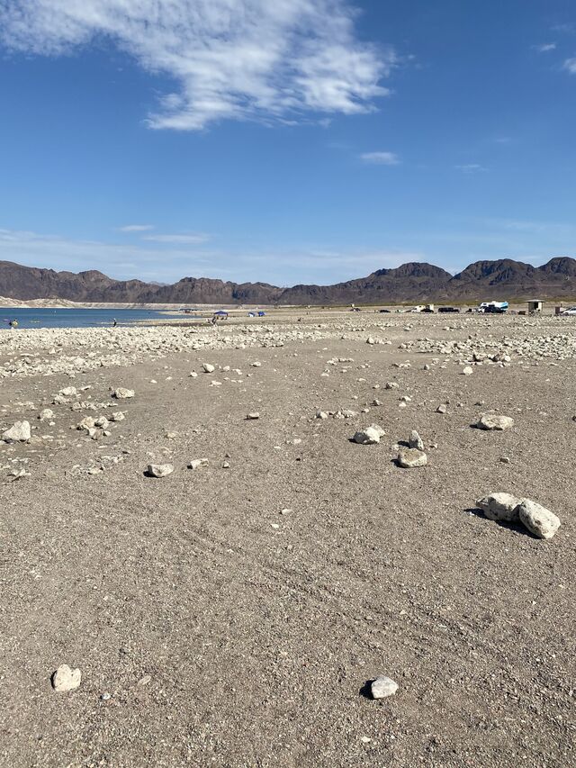
But the lake is shrinking, faster and sooner than hydrologists and other experts predicted. A stark white band of dry rock, 120 feet wide, circles its craggy perimeter, marking how far the water line has fallen in the ongoing drought. Locals call it the “bathtub ring.”
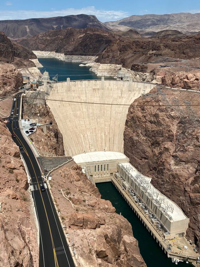
Walking Lake Mead’s shoreline in the blistering July sunshine offers other reminders of the receding water. Swimmers gather in an area that they call a beach but is really an exposed portion of the reservoir’s rocky floor — some distance from the place further inland where people used to sunbathe. Marina ramps are closed because the water isn’t high enough to properly launch a boat. Formerly submerged infrastructure supporting enormous “straws” that suck water from the reservoir to be delivered to Las Vegas now tower above the lake. Saddle Island, home to a major water treatment plant, is so parched, it’s no longer an island — it’s a peninsula.
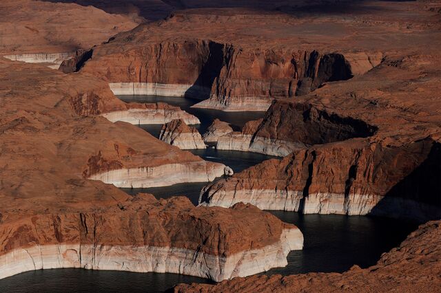
Lake Mead and its troubled fellow reservoir upriver, Lake Powell, symbolize a broader threat. The entire Southwest has been baking in a 21-year drought and in this summer’s successive heat waves, which have also roasted Northwestern states. How communities and businesses everywhere live with this change — how they adjust to the idea that water is a precious, waning resource rather than an abundant, inexpensive commodity — is being tested in the Southwest. Dry, sizzling summers and warmer winters that restrict water supplies may now be the norm, courtesy of a permanently altered climate.
“A lot of our problems are creeping. They aren’t acute. Drought isn’t something that just happened here — it’s been going on for two decades,” says Kristen Averyt, Nevada’s climate policy coordinator and a research professor at the University of Nevada at Las Vegas. “But this recent heat wave should be sobering because this is arguably the most significant heat wave North America has experienced. And it’s here to stay.”
Interlocking legal agreements, built on earlier pacts dating back at least a century and layered atop a hodgepodge of local rules, govern how Colorado River water is shared among seven states, Native American nations and Mexican territories. In 2019, after years of thorny negotiations over a diminishing water supply, states and the federal government signed the Drought Contingency Plan, which lays out how water will be doled out if a shortage occurs.
When the plan was signed, Arizona and Nevada accepted reduced water allocations from Lake Mead — a feature of the DCP known as Tier Zero. California was initially spared from cutbacks. Colorado, New Mexico, Utah and Wyoming are served water from Lake Powell, where water levels have plunged; a shortage may be declared next year.
The hope was that these first, incremental steps might slow Lake Mead’s depletion and delay more severe restrictions. The reservoir’s surface elevation at Tier Zero was 1,090 feet, well below its peak of 1,226 feet in 1983. When the reservoir drops to 1,075 feet, it will become Tier 1 — which represents just 40% of total capacity. (Other, more wrenching shortfalls accompany plunges to Tiers 2, 2a, 2b and 3.)
Lake Mead Reservoir Elevations
A cut of 720,000 acre-feet of water represents about a year’s supply for more than 2 million households. Arizona’s initial cuts will fall on farmers, however, and not municipalities or industry.
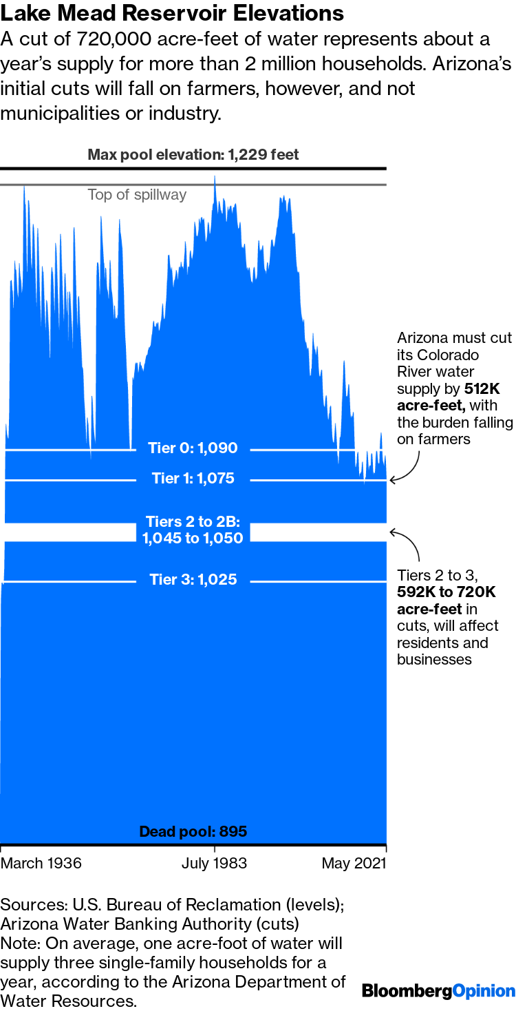
Note: On average, one acre-foot of water will supply three single-family households for a year, according to the Arizona Department of Water Resources.
Sources: U.S. Bureau of Reclamation (levels); Arizona Water Banking Authority (cuts)
“Tier 1” looms over conversations about drought in the Southwest in the same way that “rolling blackouts” haunts certain conversations elsewhere. Tier 1 has entered the Southwestern argot because it is the benchmark that will trigger a formal declaration of a water shortage, expected in August. Tier 1 also foreshadows further belt-tightening. It suggests that a region of deserts and mountains that has spent a century growing explosively might have to consider downsizing — or, perhaps, right-sizing.
Tier 1 will most heavily impact Arizona, due to legal and political peculiarities stemming from water battles of the past. Other Colorado River basin states will face more onerous rationing regimes only when further DCP tiers are reached. Then, Arizona’s burden will worsen as well, but even Tier 1 inflicts a severe blow. The state will lose nearly a fifth of the water it has been drawing from the Colorado River.
It has decided that farmers and ranchers will absorb the entirety of this cut, temporarily sparing municipalities and industry. Farmers in Pinal County, an Arizona breadbasket, expect deliveries from the Colorado River to drop by half next year and disappear altogether in 2023.
“We’re not sure how long we can hang on. We’re getting nervous about it,” Nancy Caywood, a Casa Grande farmer, recently told a local TV station. “We seriously don’t know what to do. We’re hoping for rain. We’re praying for rain.”
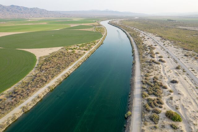
Farms need outsized amounts of water to grow crops. During wet years, so much water could be channeled to central Arizona that it was possible, if inadvisable, to grow cotton, corn, barley and alfalfa in the desert. That may no longer be the case. But farms aren’t the only businesses that need water. Cutting-edge factories, including semiconductor plants, require millions of gallons daily. Two heavyweights in the chip industry, Intel Corp. and Taiwan Semiconductor Manufacturing Co., plan to build major plants in Arizona, and those operations will be water-dependent, too. Real estate developers, which routinely unveil master-planned communities in fast-growing Phoenix suburbs and in the Sonoran Desert, also need water, and some groundwater supplies are already strained.
Arizona has spent decades preparing for droughts, and the state believes it can use water-sharing agreements to aid farmers when the first big cutback happens. Chipmakers have become deft water recyclers and say that they can work with a more limited supply. Developers claim to be observing strict local regulations on sustainable water usage. But even experts who have spent their careers tackling water-management issues in the state recognize why this moment resonates.
“We’re about to declare the first water shortage ever on the Colorado River,” says Chuck Collum, a program manager for the Central Arizona Project, an agency that delivers Lake Mead water to the state. “It will be emotional to be here when that happens.”
“This isn’t just an Arizona problem. This is a Colorado River basin problem,” he adds. “We’re linked by this river, so problems in Phoenix are problems in Las Vegas.”
And problems in Las Vegas will find their way elsewhere, too.
•••
The Colorado River, formed by tectonic collisions, settled into its present, 1,450-mile course about 6 million years ago, carving the Grand Canyon as it flowed southwestward from the Rocky Mountains to its delta in the Gulf of California. Its unpredictability and turbulence humbled the Native Americans who settled around it thousands of years ago and considered its waters sacred. The river remained untamed until the 20th century, when the Hoover Dam was built.
The dam is an alabaster fortress, capped with Art Deco flourishes, and so soundly engineered it is expected to last a millennium. To absorb the financial risks of building it, six major construction companies combined forces in partnership with the federal government. A model of ingenuity, it is the closest approximation in the U.S. to the Great Pyramids, and required as much hubris.
Before the dam was built, the Colorado River swung between seasonal floods and withdrawals, alternately swamping and drying out Southwestern farms, homesteads and towns. It was “an American Nile awaiting regulation,” proclaimed a Los Angeles engineer and federal hydrographer, Joseph Barlow Lippincott, in 1912. It needed to be corralled, he said, “in as intelligent and vigorous a manner as the British government has treated its great Egyptian prototype.”
In 1922, California, eager to feed a booming economy and population, began lobbying the federal government to dam the river. It also wrangled water so aggressively that the six other basin states worried they’d lose their share. That same year, the Colorado River Compact was drafted to settle those fears, with water from the river allocated in annual batches measured in acre-feet — the amount needed to cover an acre of land to a depth of one foot. (Today, a single acre-foot is enough to serve three households annually, depending on usage.) The states estimated in 1922 they would have 16.5 million acre-feet of river water available annually, a figure that decades later proved to be wildly optimistic.
Court battles between Arizona and California over water rights took decades more to settle and left the federal government as the arbiter of allotments in the region. But the 1922 compact allowed the basin states to jointly tame the river, ultimately with the Hoover Dam. The river was diverted, the dam’s 726-foot concrete wedge filled the canyon, and the water was allowed to rush back in.
For the first time, the Colorado River was being directed and managed with a giant faucet. Lake Mead became so voluminous that its weight deformed the earth’s crust and in the 1930s triggered more than 600 minor earthquakes. Like dams before and after, Hoover Dam also disrupted plant, marine and wildlife habitats; unsettled sediment deposits; and created reservoirs that emitted methane and other greenhouse gases.
All that water also enabled the extraordinary manufacturing, agriculture, technology and residential boom in the Southwest. The water’s eventual decline, which started to be felt at the turn of this century, stands to have an equally powerful impact.
•••
During a six-day stretch in mid-June, warm Pacific Ocean air carried along the jet stream became trapped in the atmosphere over Western states — a phenomenon known as a “heat dome.” Record-high temperatures occurred in several places, extending the worst megadrought in centuries, amplified by climate change.
Soaring temperatures have also reduced runoff from the Rocky Mountain snowpack that replenishes the Colorado River, and have caused Lake Powell and Lake Mead to evaporate more rapidly. Yet the coming shortages have been anticipated.
“We are not in a state of panic. We’re prepared. We knew it was coming and we’ve been storing water underground,” says Sharon Megdal, director of the University of Arizona Water Resources Research Center. “But the situation is bad and it’s growing worse sooner and faster than we thought it would. Some aren’t going to be able to continue business as usual. They will have to adapt.”
Southwesterners bristle at the idea that they shouldn’t live in such a forbidding region, or that they have somehow overlooked the peril of dwindling water supply. Yes, Las Vegas casinos have waterfalls and Venetian canals, and Phoenix has golf courses, but Southwesterners say such oddities don’t represent their relationship to water. And in fact they don’t.
Arizonans use less water now than they did in the 1950s, despite a population boom. A pivotal factor in that shift was refashioning agricultural lands for residential living; homes use much less water than farms do. But smart planning also played a role. Legislation the state passed in 1980 regulates water use, conservation and land development. Projects built since then have to show they have access to a 100-year water supply (though some developers have found ways around that mandate).
The state also diversified its sources of water. In the 1950s, 69% of its supply came from groundwater. Now only 41% does, as the chart below shows. Water from the Colorado River accounts for the lion’s share of that difference. (Most of Arizona’s water — 72% — is used by farmers. Municipalities and industry use the rest.)
Arizona’s Water Sources and Uses
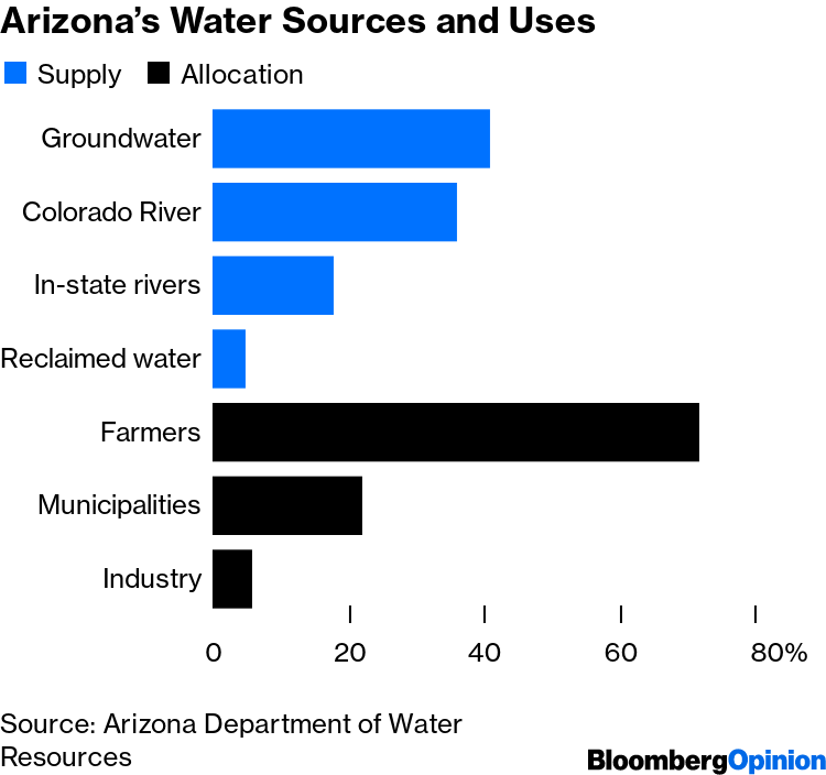
Source: Arizona Department of Water Resources
Arizona has also spent the past 25 years storing about 3 trillion gallons in a network of “water banks” — a supply big enough, the state says, to serve Phoenix for 30 years. Part of that supply was created through artificial above-ground pools that gradually seep through the soil and “recharge” subterranean aquifers.
But Arizona’s regulatory apparatus isn’t airtight. Some landowners and farmers aren’t bound by its rules and can pump groundwater at will. And there are no uniform legal guidelines around various uses of surface water and groundwater.
While Arizona now uses less groundwater than it did decades ago, waning supplies from Lake Mead have forced it to reconsider that strategy. As the shortage deepens, water banking is likely to be eliminated. Sprawling suburban subdivisions depend on groundwater stocks that will be difficult to replenish. The prospect of aggressively tapping other groundwater supplies in rural areas to make up the difference has sparked a heated debate about environmental impacts — and basic fairness.
A group of University of Arizona researchers who in 2017 wrote a detailed analysis of the state’s water usage found that some of the lofty conservation goals established in 1980 won’t be met, and that the balance between extracting and replenishing groundwater has fallen dangerously out of whack.
In March, Intel announced that it will spend $20 billion building its two new semiconductor plants in Arizona. TSMC, which has been scrambling to secure water amid a drought in Taiwan, has already broken ground on its Arizona plant, which is said to cost as much as $35 billion.
This spending is part of a larger manufacturing renaissance in Arizona, built on the strategic advantages, talented workers and lower operating costs the state offers certain businesses. Chipmakers also need to build their factories as far as possible from seismic activity, because even slight rumblings can upend production runs. Earthquakes occur less frequently in Arizona than they do in nearby states such as California.
But a chip fab, depending on its size, can use 2 million to 9 million gallons of water a day to produce a smaller amount of the ultra-pure water it needs to clean components. TSMC has said it recycles 87% of the water it uses. Intel says its goal is a recycling program that generates “net positive water use” in Arizona. It has funded 15 water restoration projects for the state that it says will potentially restore 937 million gallons annually.
Neighboring Nevada has also spent decades preparing for water shortages, and the crisis at Lake Mead will affect it less in the near term. Although Las Vegas is one of the country’s fastest-warming cities, the Southern Nevada Water Authority says its customers conserve enough annually that the state can readily absorb shortages. From 2002 to 2020, the Las Vegas Valley reduced its per capita water use by 47%.
Nevada has longstanding water restrictions in place and is planning to ban ornamental grasses. Indoor wastewater is recycled and the state offers companies financial incentives to find innovative ways to conserve water. Developers were ordered decades ago to build only water-efficient homes. Although homeowners watering lawns and filling pools account for the single biggest use of water in Las Vegas — more than all the casinos and hotels consume — aggregate water usage in Nevada has dropped even as the state’s population has grown.
Experts such as Averyt, Collum and Megdal — all committed to the Southwest’s future — emphasize how crucial it will be to strengthen conservation regulations and water laws across the region.
Water is still sold at rock-bottom rates — lower than the cost of electricity — and to facilitate rationing and responsible usage, prices will need to rise. Israel, another desert community, offers a good model for how to orchestrate such a pricing shift. A lot of residential water in states like Arizona is used outdoors, to water plants and trees and fill swimming pools, and this offers an easy target for cutbacks. Seawater desalination plants and wastewater recycling facilities have sprung up around the region. Greater public education about water usage and availability — as San Antonio, Texas, has provided its residents — would also help.
But there’s no single, fast solution. “It’s a story that’s going to unfold over years and years,” says Collum. “It’s going to be incremental, important engagement. There’s no single masterstroke that can fix it.”
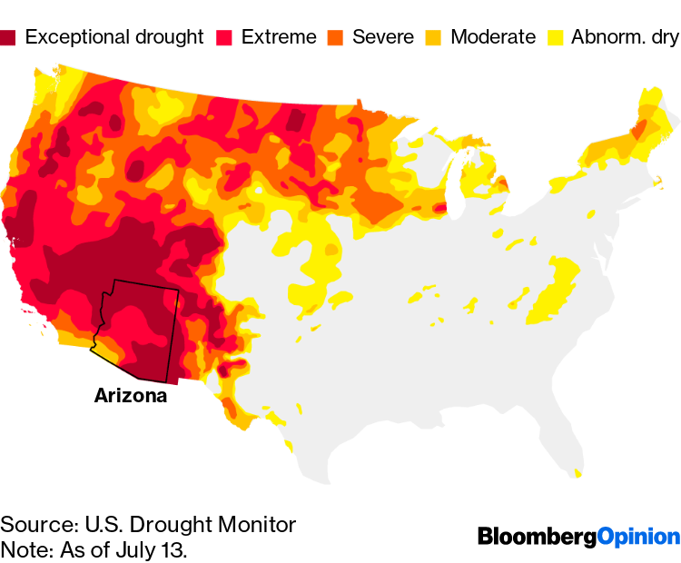
Note: As of July 13.
Source: U.S. Drought Monitor
If the drought persists or accelerates, then this becomes a race against time. The Colorado River Compact, drafted in the wake of two decades of unusually abundant rains, allocated more water than the river could provide. Now Mother Nature is forcing the Southwest to adjust.
The Hoover Dam’s original hydraulic turbines have been replaced with more efficient models able to keep spinning in shallower water. These can operate until the reservoir’s water level falls to 950 feet, about 125 feet below where it is now, and then they stop working. At a level of 895 feet, water can no longer leave the reservoir — at which point Lake Mead is labeled a “dead pool.”
A reservoir and dam that one day are unable to provide water and electricity will have outlasted their usefulness. And that will be proof — if more is needed — that the ravages of climate change are at hand.