
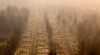
More Americans Are Moving Into Fire-Risky Areas
In the first year of Covid, migration increased into places that have seen recent wildfires — even as blazes intensify.
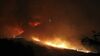
Powerful winds, dense chaparral and a loose wire on a utility pole: That was the lethal combination that ignited more than 96,000 acres north of Los Angeles in November 2018. The Woolsey Fire destroyed 1,500 structures and killed three people as it spread across Thousand Oaks, Calabasas and Malibu, burning over the Santa Monica Mountains all the way to the Pacific’s edge.
For months, no homebuyer would come near, remembers Dave McLaughlin, who sells homes and lives in the area. The fire had left parts of it singed so badly they resembled a moonscape. When the first wave of coronavirus caused another dip in home sales, he thought he’d need a new line of work.
Then something odd happened: Demand for houses went into overdrive. By the end of 2020, McLaughlin had sold as much property in these wildfire-torched communities as any year in his career.
“Only a few clients in the last year or so have told me they don’t want to live here because the fire risk is too great,” he said from his own home on Malibou Lake, an affluent neighborhood where dozens of homes were destroyed in 2018 and which has seen surging sales in the past year. “Covid erased people’s wildfire fears.”
Wildfire Zones Grow in Popularity

Tracts touched by fire since 2010
Tracts not touched by fire since 2010
Shaded areas represent margin of error
PRE-COVID
COVID
12 household
moves per 1K
8
4
0
-4
-8
-12
-16

Tracts touched by fire since 2010
Tracts not touched by fire since 2010
Shaded areas represent margin of error
PRE-COVID
COVID
12 household
moves per 1K
8
4
0
-4
-8
-12
-16

Tracts touched by fire since 2010
Tracts not touched by fire since 2010
Shaded areas represent margin of error
PRE-COVID
COVID
12 household
moves per 1K
8
4
0
-4
-8
-12
-16
That appears to be the trend across the U.S. Only 4.6% of U.S. households live in a census tract that’s been burnt by a wildfire since 2010. But their numbers have grown since the pandemic: Compared to the previous 12 months, the number of households that moved into areas with a recent history of wildfire climbed 21% between March 2020 to February 2021, according to a Bloomberg CityLab analysis of change-of-address data from Melissa, a global data intelligence and address analytics company, and wildfire burn areas from the National Interagency Fire Center.

2021 FIRES
The Bootleg Fire in Oregon burned over 400,000 acres between Jul. 6 and Aug. 15th, when it was contained.
The Dixie Fire is the largest single fire in the history of California, and has burned almost 1 million acres so far.
The Caldor Fire has burned over 221,000 acres since it started mid-August. It's still burning.


Not all of these places saw severe damage from the flames. Still, the accelerated migration into flammable territory during the pandemic contrasts with what happened in areas that haven’t burned since 2010, which saw a 15% decline in household moves during the first year of Covid-19 compared to the previous year. Propelled by affordability pressures, a desire for space amplified by pandemic life, and in some instances a misplaced sense of security, it is part of a much longer-term trend: More people are living within the wildland-urban interface, or “WUI” — the edge between highly developed communities and highly flammable mountains and forests. That raises the level of risk to life and property, as well as the cost, particularly as wildfires become more destructive, frequent and hard to predict.
“People tend to underestimate their fire risk,” said Jesse Keenan, a professor of real estate at Tulane University who studies the effects of climate change on the built environment. “We’re starting to see consistently that fire is burning in ways we haven’t before.”
Dried-out forests, hotter temperatures and more ferocious wind patterns are combining to break burn records year after year. In 2020 alone, nearly 17,700 structures were destroyed or damaged in wildfires across the U.S., saddling insurers with an estimated $7 billion to $13 billion in claims in just four of the most fire-prone states. By far the majority of that wreckage was in California, which has seen 8 of the 10 largest fires in its history in the last four years. There, 2020 set the record for most acreage consumed as well as the most the state has spent on emergency fire suppression. That trend of costly devastation is expected to continue into 2021, as the Dixie Fire, the single largest in California history, continues to burn north of Sacramento.
The financial impacts are largely weathered by local communities. Less than 10% of the total expenses incurred by wildfires are related to suppression, which is generally paid for by state and federal government, according to a report by Headwaters Economics, a think tank. The rest of the cost is from long-term, local rebuilding efforts such as road repairs, watershed restoration and home reconstruction. “All the costs, on all fronts, are going up,” said Kimiko Barrett, who researches community wildfire planning and policy at Headwaters Economics.
California’s Wildfire Footprint

2021 fires
2010-2020 fires
Urban areas
The Camp Fire of 2018 consumed the entire town of Paradise, CA, sending a wave of evacuees to neighboring Chico—which became the fastest growing city in California in 2019.
CHICO
PARADISE
By early 2021, moves to the Paradise area spiked 120% as many people returned.

Urban areas
2021 fires
2010-2020 fires
The Camp Fire of 2018 consumed the entire town of Paradise, CA, sending a wave of evacuees to neighboring Chico—which became the fastest growing city in California in 2019.
CHICO
PARADISE
By early 2021, moves to the Paradise area spiked 120% as many people returned.
Yet the movement trends are seen throughout the West, where significant portions of the population already live in fire-prone areas. In California, 12% of households live in an area that has seen wildfire since 2010. That share is 38%
 in Idaho, and 19%
 in Utah. These were also the top three states with the highest number of moves last year into tracts recently touched by fire.
“These are places that have burned and will burn again and despite that -— despite the very visible indication of that in many cases — people are still moving,” Barrett said.
Motivations vary, with many people choosing to live in areas with forested backyards and access to the outdoors, with more square footage for their dollar. In other cases, people are being pushed out of cities due to housing constraints and have few choices but to settle in further-out areas.
A sample of fire-touched tracts that saw some of the biggest increases in new arrivals is a window into that spectrum. While data available from Melissa is based on U.S. Postal Service changes of address and does not include all U.S. moves, it is comprehensive enough to capture trends. The appetite for housing in these vulnerable areas can also be seen in jumps in home prices.
In Butte County, California, the Camp Fire killed 86 people and virtually leveled the town of Paradise in 2018. That disaster has been held up as an early example of what climate change had in store. And many experts expected it to change the trajectory of WUI settlement.


But in the first year of the pandemic, some 650 more households moved into the Paradise area than in the year prior, when household numbers plummeted following the fire. Many of them were fire victims who rebuilt or resettled there after living away, partly because it was far more affordable than other nearby areas. In surrounding Butte County — which includes the city of Chico, where many Camp Fire refugees landed — housing demand has also grown.
“Moving to Chico was an option, but the housing market was so hot there — we didn’t want to pay for something that we didn’t really want,” said Alana Imrie, a fisheries biologist who lost her Paradise home in the Camp fire but moved back in November 2020. For two years, she and her husband and two teenage daughters bounced between short-term rentals via friends before moving into a home rebuilt on the same lot that had burned.
In other parts of the U.S., many of the hottest housing markets are in suburbs and exurbs with a recent history of wildfire. On the outskirts of the Provo-Orem area, Saratoga Springs, Utah, saw 1,160 more households moving in than out during the first year of the pandemic, according to data provided by Melissa. That is despite the June 2020 blaze that forced the evacuation of roughly 13,000 residents and another major wildfire season in 2012. Officials warned residents once again this summer to use extreme caution with fireworks and other flammable materials.
But wildfire risk wasn’t a factor for Charlotte Peterson, a nutritional therapy practitioner who moved to the city with her husband and two small children in January 2021 in order to be closer to family. The real estate agent who sold them their new house didn’t mention last summer’s fire, she said, though she had been aware of it: An aunt and uncle had been in the evacuation zone. But only in Saratoga Springs could they get an offer on a house accepted. “We looked all over the surrounding area, and everywhere, houses were going so quickly,” she said. “Then we found this one, and there wasn’t a fight to go get it.”
Then there were people who flocked to the Boise, Idaho, area, one of the most touted destinations for people fleeing higher-cost housing markets in Oregon and California. Tracts in Ada County, where the Table Rock fire burned nearly 2,500 acres and destroyed one home in 2016, saw 1,675 more households move in than out during the first year of the pandemic.
Home Values in Ada County Increased More Than National Averages

Mid-size metros: national average
Large metros: national average
COVID-19 PANDEMIC
60%
40
20
0
-20
April 2019
April 2020
April 2021

Mid-size metros: national average
Large metros: national average
COVID-19 PANDEMIC
60%
40
20
0
-20
April 2019
April 2020
April 2021

Mid-size metros: national average
Large metros: national average
COVID-19 PANDEMIC
60%
40
20
0
-20
April 2019
April 2020
April 2021


Officials have warned that almost nowhere in Idaho should be considered low risk for ignition, with a history of some of the country’s largest wildfires in terms of acreage. Historically, sparse population has meant those blazes have posed relatively little risk to humans. But Idaho was the second fastest-growing state in the latest U.S. census, with much of the new development pushing deeper into that flammable wilderness. Many newcomers aren’t familiar with the ignition risks, said Alicia Ralston, a real estate agent in Ada County, where home prices have climbed 53% since March 2020, according to the Zillow Home Value Index.
“We always bring the conversation up, and a lot of people look at us like it’s the first time they’ve thought about it,” she said. “Some will follow up with thoughtful questions, and others move right to asking how many garages there are or if it has a six-burner stove.”
The overall trend into these areas is not altogether surprising. Living on the edge of wilderness has been held up as an ideal in American culture since the country’s founding, while the entrenched forces that have kept new housing construction in major cities at historic lows have meanwhile driven new supply further into the boonies. The pandemic put new premiums on having home offices and roomy backyards, but it is part of a much longer rush toward the exurbs as Americans seek more living space at lower costs. A 2018 study led by Volker C. Radeloff at the University of Wisconsin, Madison found that more than one-third of new homes built between 1990 and 2010 were in the wildland-urban interface. Cheap mortgage rates have meanwhile made these markets more accessible.
“Covid didn’t really cause this. It just accelerated something that was well in the works,” said Keenan, the Tulane professor. “People tend to value the amenities of a home more than the risks it might carry.”
That fact that many people don’t weigh wildfire risk very heavily in their housing decisions is partly due to imperfect information, said Keenan and Barrett: For example, most states do not require sellers to disclose wildfire risk to new buyers, and tools for assessing that risk are still in their nascency. California has strengthened building codes in response to wildfires, requiring the use of ignition-resistant materials and defensible space around new homes. But such regulations are still the exception on a national level, and it’s still possible to get insurance policies in most high-risk areas — even in California, where insurers are currently banned from denying coverage in wildfire-prone communities.
What’s more, memories are short, and people sometimes assume that because an area has already burned, it won’t burn again for a long time.
But that may not always be the case. Eight months after Imrie and her family moved into their new home in Paradise, the Dixie Fire ignited — starting in nearly the same place as the Camp Fire had. While the town was left unscathed, the close flames and smoke meant Imrie kept her car loaded up and ready to evacuate for a week straight. Reliving the trauma of 2018 triggered conversations with her husband about moving somewhere else. But with family on the West coast, she said, it’s hard to know where it would be safer that they could also afford. “We’re all over the place with it,” she said. “It’s hard, because climate change is real and our environment is changing.”